Lake News

June 15 – Boat Launch Reopens – Boaters Urged to Use Caution

Town Hall has informed us that the boat launch is now officially open. Boaters are advised to use caution and operate at their own risk, as a significant amount of floating debris remains on the lake following the recent high-water event. Although the water level has receded to near normal summer levels, submerged and floating hazards may still be present. Please maintain a safe speed, keep a sharp lookout for debris, and exercise extra caution while on the water.

Boat Launch Remains Closed – June 13–14 Weekend

The Madison Board of Selectmen has decided to keep the public boat launch closed for the weekend of June 13–14 to help prevent boat wakes from causing damage to shorelines and waterfront property.

As of 8:00 AM on Saturday, June 13, the lake level had receded approximately 4 inches from its extreme flood level and continues to fall. While conditions are improving, water levels remain elevated, and the closure is intended to minimize additional shoreline erosion and property damage.

We appreciate everyone’s cooperation and will provide updates as conditions change.

Lake Level Update – June 11, 7:00 PM

Following last night’s unexpected deluge of approximately 3.5 inches of rain, the lake reached record-high water levels. As of 7:00 PM on Thursday, June 11, with the dam gates fully open, the water level has receded by approximately one inch. We will continue to monitor conditions and provide updates as the lake level changes.

Boat Launch Stickers

Boat launch stickers are available at Madison Town Hall during open hours (Monday–Thursday, 8 AM– 4 PM). You can also use this link for mail-in instructions and a list of the information you’ll need to provide.

Time to Renew Your Membership and Support SLAM’s Vital Work

It’s that time of year again—membership renewal season! Your support enables SLAM to continue its mission of protecting and preserving our lake. The water is up, boats are launching, and our dedicated Lake Hosts are already at work. Water testing is scheduled, the Watershed Management Plan is moving forward, and we’re actively advocating for important lake issues. But threats to our lake remain—and we need your help to keep up the momentum. Please consider renewing your membership or making a donation today: Donate here or Join or renew your membership here

Thank you for being part of this important work!

Dam Boards Installed | Water Levels near Normal for Summer

The boards are in on the Silver Lake dam, and May water levels are near their normal summer range. The dam has some leaks and aging cracks, but it is not in any immediate danger. A new Dam Committee has been formed to evaluate long-term solutions, and a new Selectman has applied for a federal grant to help fund the eventual dam replacement. In the meantime, steady as she goes

New Hampshire Lake – LakeSmart Program

Lake Smart

If you’ve noticed LakeSmart signs around Silver Lake, they mark properties participating in the NH Lakes LakeSmart Program—a voluntary initiative that helps homeowners protect the lake through practical, science-based improvements. The program focuses on reducing runoff, limiting erosion, and maintaining healthy shorelines.

A LakeSmart visit includes a free, non-regulatory evaluation of your property, along with personalized recommendations. These may include improving drainage, adding native plant buffers, or stabilizing shoreline areas—all aimed at keeping pollutants out of the lake.

Taking part in LakeSmart not only supports cleaner water and better habitat, it can also improve your property’s resilience and curb appeal. When more homeowners participate, the collective impact helps preserve Silver Lake for everyone to enjoy.

To learn more or get started, go to the NH Lakes LakeSmart web site.

September 12, 2025 Surface Layer Survey Details

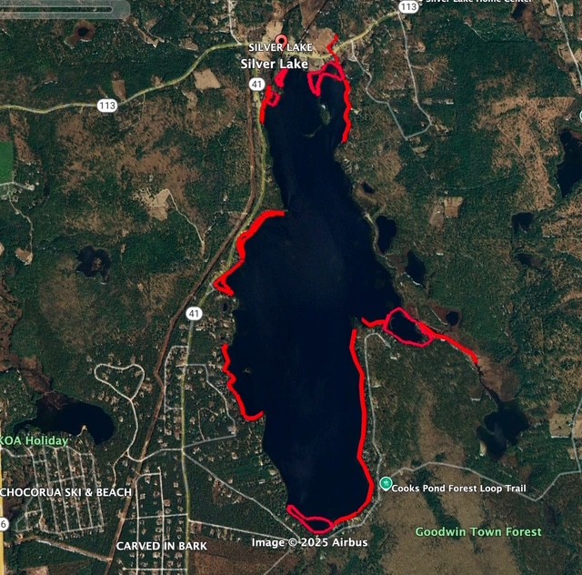
Here are the final results from the lake survey by Cliff Cabral of New England Milfoil – this time with a map that shows the “hot spots” that our weed watchers should be paying closer attention to:  

Referencing the below map: We estimate that approximately half of the Silver Lake shoreline is rocky/sandy, making it difficult for plants to establish themselves; while the other half would be conducive to plant/invasive growth (indicated in red on the map). All of the underwater islands consist of rock piles and thrushes, and no other plant life. 

We are happy to report that we found no evidence of invasive plants!

Protecting Our Lake: A look back at our lake host program in 2004

Read how SLAM’s Lake Host Program’s early efforts—highlighted in this 2004 article—helped shape a lasting fight against exotic aquatic plants in our lake.